Showing posts with label GPS. Show all posts

Tuesday, November 28, 2006

GPSMAP 60CS

The GPSMAP® 60CS and GPSMAP 60C are new all-purpose units—packed with exciting new features and delivering the kind of color that consumers want in their handheld GPS’s. These lightweight, rugged, waterproof units raise the bar to offer a 256-color, highly reflective display that provides easy viewing in almost any lighting condition. This transreflective TFT provides excellent viewing while maximizing your battery life (20 hours, typical use).
Both the GPSMAP 60CS and GPSMAP 60C are packed with extra features, including rapid automatic route calculation, an integrated outdoor calendar, a dedicated geocaching mode, and indoor/outdoor GPS games that turn the outdoors into a giant gameboard.
The GPSMAP 60CS also offers an electronic compass and barometric altimeter for highland adventures. These sensors, when combined with GPS technology, provide enhanced bearing and elevation readings.

GPSMAP 60CS Features:


  • Electronic compass displays accurate heading while standing still

  • Barometric sensor with automatic pressure trend recording

  • Sunlight-readable display with 256-color transreflective TFT display (1.5" W x 2.2" H; 2.6" diagonally); color operating system with new look-and-feel

  • Faster processor, with auto routing, turn-by-turn directions, and audio alerts along city streets or trails when using MapSource® City Select® or 24K Topo software (optional software)

  • 56 MB of internal memory for storing map detail

  • Permanent user data storage

  • Each day’s best hunting and fishing times—along with sunrise/sunset times—on the integrated Outdoor Calendar

  • Special geocaching navigation mode

  • Geolocation games, such as Virtual Maze, Nibbons, Geko™ Smak, Memory Race, and Gekoids

  • Fast map transfer, with support for both USB and serial port interfaces

  • Detailed basemap with general map data, including highways, major roads, river, lakes, and borders

  • Dedicated "mark", "page", "enter", "quit", "menu", "find", and "zoom out/in" buttons; four-position rocker pad

  • 2.4" x 6.1" x 1.3" (W x H x D) unit dimensions

  • Weighs 5.4 ounces (without batteries), 7.5 ounces (with batteries)

  • WAAS GPS receiver with accuracy to 10 feet in North America; built-in quad-helix antenna for better satellite reception

  • 20 hours of battery life under typical-use conditions (uses two "AA" batteries)

  • Multi-platform navigation for easy navigation in a car, in a boat, or on foot

  • Accepts data from MapSource products. See the MapSource Compatibility table (top right) for a list of software that Garmin recommends with this product.
    Waterproof to IEC 60529 IPX7 standards (can be submerged in one meter of water for up to 30 minutes)

  • 50 reversible routes, 10,000 track points with TracBack® technology (navigate to any track point on the displayed map), and 1000 waypoints with additional graphical icons for location identification

  • Proximity alerts for anchor drag, arrival, off-course, proximity waypoint; built-in alarm clock

  • User-configurable track-line color, waypoint projection, display color scheme, large-numbers option, audio tones, and pages (turn on/off main pages or change the sequence in which they appear)

  • Elevation computer provides current elevation, ascent/descent rate, minimum and maximum elevation, total ascent and descent, average and maximum ascent and descent rate

  • Trip computer provides odometer, stopped time, moving average, overall average, total time, max speed, and more

GPSMAP 478

On land or water, you're ready to go
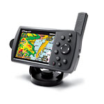
Go n land or water, you're ready to go from box to boat to dash with the portable and versatile GPSMAP® 478. This combination color chartplotter and land navigator comes preloaded with U.S. marine charts utilizing elements of the latest BlueChart® g2 technology, in addition to detailed street-level mapping. Optional weather and sonar capabilities combined with the ability to conveniently add plug-in data cards, let you easily add more maps and features — making this one incredible GPS navigator for land and sea.
Preloaded and Portable
From curbside to dockside, the GPSMAP 478 has you covered — no downloads or computer required. Its built-in marine charts utilize the latest BlueChart® g2 technology and feature coverage for all U.S. coastal areas, including Alaska and Hawaii. Our g2 mapping technology offers a smoother, more fluid presentation on your screen.
For road trips, the 478 along with its freshwater counterpart, the GPSMAP 378, come preloaded with City Navigator NT detailed street maps for North America and include automatic routing with voice guidance along with an industry-leading database with more than six million points of interest — including hotels, restaurants, gas stations, marinas, attractions and more. An included marine mount and automotive kit make it a snap to transfer the unit from boat to car.
Up-to-date Weather
See real-time weather displayed on the 478’s high-resolution 256-color sunlight-readable TFT display with the purchase of the GXM 30 antenna (sold separately) and subscription to XM WX Satellite Weather. View vital weather data, such as NEXRAD radar, storm cells, wind speeds, surface temperatures, forecasts and more than a dozen other weather attributes directly on the unit’s display — so you can spend more time enjoying the water and less time worrying about the weather.
With the GXM 30 antenna, you also have the option of receiving XM Satellite Radio’s 150 plus channels of commercial-free music, sports, news, talk and entertainment programming. Weather and audio options travel with your plotter, whether you’re navigating on land or sea.
Sonar Capability
If fishing’s your game, pair the 478 with the GSD™ 21 remote sounder module to add sonar capability. The GSD 21 is Garmin’s “black box” sounder, which offers 4,000 watts of power peak-to-peak (500 watts RMS) in a dual-frequency transducer (purchased separately).
Plug-and-play Additional Mapping
Optional software available on plug-in Garmin data cards, lets you instantly add new maps to your GPSMAP 478 — without connecting to your computer. Easily customize map data for your adventures on land or sea with our optional MapSource® cartography. Plug-in the latest BlueChart g2 data cards to add “real picture” aerial photo reference, detailed coastal roads and points of interest. For inland coverage, try our preprogrammed U.S. Inland Lake data cards. See the MapSource Compatibility table (top right) for a list of software that Garmin recommends with this product.
The GPSMAP 478: Loaded and ready for action, right out of the box

GPSMAP 478 Features:

  • Receiver: WAAS-enabled, 12 parallel channel GPS receiver
  • Display: 3.8-inch diagonal, 480 x 320 pixel, 256-color TFT screen with adjustable LED backlight
  • Unit dimensions: 5.7"W x 3.2"H x 1.9"D
  • Waypoints: Stores 3,000 waypoints and 50 reversible routes
  • Tracks: 10,000 point automatic track log saves up to 15 tracks
  • Battery life: Rechargeable lithium-ion battery offers 4 to 15 hours of use (4 hours with GXM 30 and 15 without GXM 30)
  • Water resistant up to IEC 60529 IPX7 standards (submersible in one meter of water for 30 minutes)
  • Preloaded with U.S. marine detail charts utilizing g2 technology
  • Built-in street navigation with voice prompts, using included cable and speaker
  • Accepts the latest (optional) BlueChart g2 data cards
  • Add optional GSD 21 for full-feature sonar capability
  • Add optional GXM 30 antenna for XM WX Satellite Weather
  • Provides tides and built-in celestial information
  • NMEA 0183 input and output
  • Removable quad helix antenna
  • Single knob tilt/swivel mount

Wednesday, November 22, 2006

YAESU - GPS - CP155

SUPERIOR PERFORMANCE AND SCREEN RESOLUTION!
The CP155 and CP155C GPS Chart Plotters from STANDARD HORIZON deliver a unique combination of features and performance at a price that is simply unmatched. Incorporating the latest receiver and display technologies the CP155 or CP155C are an excellent choice for the boater who demands optimum performance.

Designed For C-Map MAX, NT or NT+ Cartography
The CP155C is compatible to the latest C-Map MAX cartography, which has rattled off an amazing "Five for Five" winning streak that dates back to 1999 by the NMEA (National Marine Electronics Association) for "BEST ELECTRONIC CARTOGRAPHY".
Let the Sun Shine


Nothing beats the detail and impact of the CP155C colour display. However until recently boaters have been unable to use their colour electronics in an installation that would experience direct sunlight. The CP155C features cutting edge Transreflective screen technology. The result is a display that delivers uncompromised bright, vivid colour mapping detail in the toughest application, direct sunlight. The CP155C from STANDARD HORIZON says, "Let The Sun Shine"

Small in Size,Big in Performance
The CP155 and CP155C are a mere 4.4 inches high (110mm) and include a bracket and flush mounting kit allowing either plotter to be mounted in small spaces. Combining the outstanding accuracy of a 12 channel WAAS receiver, superior processor speed (RISC) and screen resolution (320x240) the CP155 and CP155C include features of plotters that cost twice as much. The built-in world map allows quick seamless panning and zooming with or without a cartridge loaded. When more detail is desired, a C-MAP cartridge can be inserted into the front-loading waterproof door. Finally, in order to make accessing data on the chart easier STANDARD HORIZON developed a unique cursor control system called ShuttlePoint. This new cursor controller allows the user to move the cursor to any position on the chart page even when the vessel is underway.

EGNOS (European Geostationary Navigation Overlay Service)
Also known as WAAS (Wide Area Augmentation System) A 12-channel WAAS/EGNOS receiver is the heart of the CP155C. WAAS/EGNOS, the latest receiver technology improves the accuracy and integrity of basic GPS signals. WAAS/EGNOS delivers pinpoint repeatable accuracy to within 3 meters of a vessel's actual position. This new technology allows every sailor to obtain the accuracy of a Differential GPS without the additional expense. The WAAS/EGNOS system currently covers the United States, Canada, Mexico, parts of northern South America plus the United Kingdom and European Continent.

Additional Features Found in The CP155 and CP155C GPS Chart Plotter
Better cursor control via unique "ShuttlePoint" controller
Simple Menu driven software
Celestial Page calculates and displays sun/moon rise/set times along with high and low water tide information
Port Services and detailed tide information available when an optional C-MAP card is installed.
User configurable data fields can be viewed in normal or large fonts
Accepts RADAR TLL input to mark and save scanned vessel positions
Marks and Route names can be up to 10 characters long. PC upload and downloading of Marks, Waypoints and Routes with optional C-MAP PC PLANNER NT software
16 selectable Icons can be displayed on the chart page to ease recognition of saved Marks and Waypoints
By connecting to the VM-3500E DSC radio, the Plotter can display polled vessels and also vessels that have transmitted a DSC distress call.·
New fish finder option (FF520)

Unique VHF Distress and Position Request DisplayUsing
Digital Selective Calling (DSC), the CPCP155 or CP155C can decode, display and log either a VHF Distress or Position Request call when input is received from a DSC equipped radio that is capable of sharing the data. Connect the CPCP155 or CP155C to STANDARD HORIZON's VM-3500E DSC VHF, and the plotter will alert you with a message whenever a Distress or Position Call is received. Should the operator select to view the received position, the plotter automatically zooms out to show both senders vessel and users vessel position directly on the chart. A second prompt asks the user whether they would like to navigate to the received vessel position, while alerting the operator to possible obstructions. Select to create a route to the received vessel position and the CPCP155 or CP155C automatically creates a route while immediately calculating important navigation data such as Distance To Waypoint and Time To Go. Connect either Chart Plotter to an autopilot and you have an integrated navigation system that eliminates the requirement for coordinate input.

3-Year Warranty - DARE TO COMPARE
yThe CP155C was designed from the ground up to take the punishment of the marine environment and is "BACKED BY A 3 YEAR WATERPROOF WARRANTY!" Dare to compare this warranty to other marine Chart Plotters.