 SUPERIOR PERFORMANCE AND SCREEN RESOLUTION!
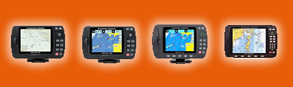
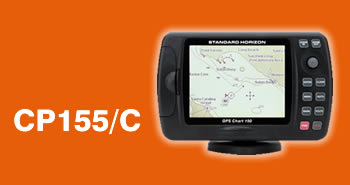
The CP155 and CP155C GPS Chart Plotters from STANDARD HORIZON deliver a unique combination of features and performance at a price that is simply unmatched. Incorporating the latest receiver and display technologies the CP155 or CP155C are an excellent choice for the boater who demands optimum performance.
Designed For C-Map MAX, NT or NT+ Cartography
The CP155C is compatible to the latest C-Map MAX cartography, which has rattled off an amazing "Five for Five" winning streak that dates back to 1999 by the NMEA (National Marine Electronics Association) for "BEST ELECTRONIC CARTOGRAPHY".
Let the Sun Shine
Nothing beats the detail and impact of the CP155C colour display. However until recently boaters have been unable to use their colour electronics in an installation that would experience direct sunlight. The CP155C features cutting edge Transreflective screen technology. The result is a display that delivers uncompromised bright, vivid colour mapping detail in the toughest application, direct sunlight. The CP155C from STANDARD HORIZON says, "Let The Sun Shine"
Small in Size,Big in Performance
The CP155 and CP155C are a mere 4.4 inches high (110mm) and include a bracket and flush mounting kit allowing either plotter to be mounted in small spaces. Combining the outstanding accuracy of a 12 channel WAAS receiver, superior processor speed (RISC) and screen resolution (320x240) the CP155 and CP155C include features of plotters that cost twice as much. The built-in world map allows quick seamless panning and zooming with or without a cartridge loaded. When more detail is desired, a C-MAP cartridge can be inserted into the front-loading waterproof door. Finally, in order to make accessing data on the chart easier STANDARD HORIZON developed a unique cursor control system called ShuttlePoint. This new cursor controller allows the user to move the cursor to any position on the chart page even when the vessel is underway.
EGNOS (European Geostationary Navigation Overlay Service)
Also known as WAAS (Wide Area Augmentation System) A 12-channel WAAS/EGNOS receiver is the heart of the CP155C. WAAS/EGNOS, the latest receiver technology improves the accuracy and integrity of basic GPS signals. WAAS/EGNOS delivers pinpoint repeatable accuracy to within 3 meters of a vessel's actual position. This new technology allows every sailor to obtain the accuracy of a Differential GPS without the additional expense. The WAAS/EGNOS system currently covers the United States, Canada, Mexico, parts of northern South America plus the United Kingdom and European Continent.
Additional Features Found in The CP155 and CP155C GPS Chart Plotter
Better cursor control via unique "ShuttlePoint" controller
Simple Menu driven software
Celestial Page calculates and displays sun/moon rise/set times along with high and low water tide information
Port Services and detailed tide information available when an optional C-MAP card is installed.
User configurable data fields can be viewed in normal or large fonts
Accepts RADAR TLL input to mark and save scanned vessel positions
Marks and Route names can be up to 10 characters long. PC upload and downloading of Marks, Waypoints and Routes with optional C-MAP PC PLANNER NT software
16 selectable Icons can be displayed on the chart page to ease recognition of saved Marks and Waypoints
By connecting to the VM-3500E DSC radio, the Plotter can display polled vessels and also vessels that have transmitted a DSC distress call.·
New fish finder option (FF520)
Unique VHF Distress and Position Request DisplayUsing
Digital Selective Calling (DSC), the CPCP155 or CP155C can decode, display and log either a VHF Distress or Position Request call when input is received from a DSC equipped radio that is capable of sharing the data. Connect the CPCP155 or CP155C to STANDARD HORIZON's VM-3500E DSC VHF, and the plotter will alert you with a message whenever a Distress or Position Call is received. Should the operator select to view the received position, the plotter automatically zooms out to show both senders vessel and users vessel position directly on the chart. A second prompt asks the user whether they would like to navigate to the received vessel position, while alerting the operator to possible obstructions. Select to create a route to the received vessel position and the CPCP155 or CP155C automatically creates a route while immediately calculating important navigation data such as Distance To Waypoint and Time To Go. Connect either Chart Plotter to an autopilot and you have an integrated navigation system that eliminates the requirement for coordinate input.
3-Year Warranty - DARE TO COMPARE
yThe CP155C was designed from the ground up to take the punishment of the marine environment and is "BACKED BY A 3 YEAR WATERPROOF WARRANTY!" Dare to compare this warranty to other marine Chart Plotters.